19 March 2025
A cruise on Milford Sound, also known as Piopiotahi in Maori, was to be the highlight of the day. However, the 119 km drive from Te Anau to Milford Sound and back was one of the most scenic and unforgettable journey we did.
Commonly known as the Milford Road, State Highway 94 is the only road access to Milford Sound Piopiotahi. There are easily accessible scenic spots like the Eglinton Valley, Mirror Lakes, Lake Gunn, Monkey Creek and short hiking trails to waterfalls or viewpoints along this road. There is also the Homer Tunnel that is bored through the sheer granite of the Darran Mountains.
There are several cruise operators offering cruises on Milford Sound at various times of the day. I prefer a morning cruise because the lighting for photography is better in the early morning and also there are better chances of spotting wildlife like dolphins, birds and seals.
I had booked a 9.45 AM cruise with Cruise Milford. Based on instructions given, we are to check in at the Cruise Milford counter (second on the left inside the Visitor Terminal) 20 minutes before departure.
Planning the drive
Cruise Milford recommended allowing at least four hours to drive from Te Anau to Milford Sound Piopiotahi if we want to stop and admire the spectacular views, or alternatively allow two hours to travel in and do our scenic stops on the return journey. Since we are doing the morning cruise, option 2 was a good idea.
There are other good tips from them which I share below:
- There are traffic lights that may delay you at the Homer Tunnel and other areas along the highway.
- There are limited safe passing opportunities on the Milford Road. If you have traffic behind you let it pass – don’t speed up on the straights.
- Take your time and enjoy. Be a safe and considerate driver.
- If you think you are going to miss your cruise you can usually be accommodated on a later cruise so don’t take unnecessary risks on your drive to Milford.
- There are public toilets at Knob’s Flat – about halfway from Te Anau to Milford
- There is NO CELLPHONE COVERAGE along the Milford Highway. There is a pay phone at Knob’s Flat and an emergency satellite phone at the Homer Tunnel
- Parking at the main car park at Milford Sound is $10 per hour. This location is approximately a 10-minute walk from the visitor terminal where we board the boat. Payment can be made by card only at the parking stations on site.
- Free parking is available at the Deepwater Basin Road Car Park (Google Map location here). The walk from this location to the visitor terminal is approximately 30 to 40 minutes.
Based on the above information, I reckoned that we had to leave Te Anau before 7 AM to allow us sufficient time (plus some buffer) to drive with minimal stops, park our car and get to the visitor terminal on time. I had planned to see Mirror Lakes and Lake Gunn on the way in, and then do the rest of the sightseeing and hikes on the way out.
Why stop at Mirror Lakes and Lake Gunn despite the time constraint?
I will share later in this post.
The timing for sunrise was a key factor in deciding my departure time from Te Anau. I wanted to be at Eglinton Valley and more importantly Mirror Lakes when there is good lighting for photos. Sunrise time was 7.50 AM at Te Anau on this day. Google map indicated that the journey from Te Anau to Mirror Lakes would take about 40 minutes. So, I chose to start my journey just before 7 AM from Te Anau so I could get to Mirror Lakes at around 7.40 AM and also arrive at Milford Sound at about 9 AM.
Drive to Eglinton Valley
There were already a couple of cars on the road as we entered the Milford Road at Te Anau. We were the third car in a convoy of 5 cars heading the same way.
As sunrise was 50 minutes away, the surrounding was totally dark and we had to rely on our car’s headlamps to light the way. I was glad I am not the lead car that had to judge every bend of the dark road ahead and set the pace. Thankfully, the lead car was proceeding at a reasonably fast but safe speed.
In a way, the drive in the darkness reminded me of my younger days when I was serving in the armed forces. We used to travel in a convoy through all sorts of terrain to our deployment ground just before first light.
 On the road to Milford Sound as first light appeared on the horizon.
Thirty minutes into the drive, the surrounding landscape became brighter as first light appeared on the horizon and over the hills. The morning mist adds to the surreal landscape as we approached Eglinton Valley.
 Approaching my first stop at Eglinton Valley.
Eglinton Valley
I chose to make a stop at Eglinton Valley while the rest of the convoy continued on. There are vehicle bays by the side of the highway for us to stop safely and enjoy the views.
Eglinton Valley was once filled with glacier ice. The valley has steep rock sides and a flat, golden tussock floor. We took a moment to snap some photos and wondered in awe at the views around us. It is a surreal place but we did not linger. We will pass this place again when we make the return trip to Te Anau.
 Eglinton Valley as viewed from the car.
 The sun is still below the horizon but the landscape looked so unreal in the twilight.

 I just love the dreamy and misty effect just before sunrise.
Mirror Lakes
Mirror Lakes is located a few minutes drive from Eglinton Valley. The lakes are so called because on a still day without any breeze, they display a perfect reflection of the Earl Mountains.
 Mirror Lakes along the Milford Road.
The best time to visit Mirror Lakes is in the early morning where the air is still and we can enjoy the mirror-like reflections from the surface of the lake. As the sun rises to heat up the ground, air current (wind) due to temperature differences will occur and cause ripples on the water surface.
That is the reason why I chose to visit Mirror Lakes on our way to Milford Sound instead of later in the afternoon.
There were a few cars parked in the parking bay at Mirror Lake, including a food truck selling hot coffee in the cold morning.
Thankfully, the observation deck is only 2 to 3 minutes from the car park.
 There is an observation deck just a few minutes walk from the roadside parking bay.
 Mirror Lakes lives up to its name in the early morning.
 Alpenglow on the mountains and mist in the air.
The sun had risen above the horizon and we could see a little of the alpenglow on the mountain top. The amount of orange glow on the sides of the mountain would grow very slightly with each passing minute. Unfortunately, we had a boat to catch and could not stay to wait for the entire mountain to be painted golden.
Lake Gunn
We made another brief stop at Lake Gunn. Just like Mirror Lakes, the alpenglow on the mountain and mist over the reflective lake was so breathtaking.


It was 8.09 AM when we left Lake Gunn. This was the last stop we made on our way to Milford Sound.
We passed by Monkey Creek which was quite scenic but did not stop. We will make a stop on our way back.
We drove through very scenic landscape with towering mountains all around us to Homer Tunnel.
Homer Tunnel
The Homer Tunnel is a 1.2 km long road tunnel. For 19 years, the builders chipped at the rocks using picks and shovels before the tunnel through the mountain was opened in 1954.
The tunnel is one-way with traffic lights. Fortunately the light was in our favour and we just joined the tail end of a long convoy of waiting cars that was driving slowly into the tunnel.
 The convoy of cars entering Homer Tunnel.
Speed limit inside the tunnel is 30 km/hr. It was a little claustrophobic since the cross-section of the tunnel is smaller than a modern, multi-lane road tunnel made using modern drilling machines.
 We could see the rough surface of the handmade tunnel as we drove through Homer Tunnel.
After exiting the tunnel, we had good views as we descended on curving roads down the hill to Cleddau Valley and on to Milford Sound,
It was about 9 AM when we arrived at the free parking area at Deepwater Basin Road. We managed to find a space in the already packed car park. From there, we took a brisk 30 minutes walk to the Milford Sound Visitor Terminal. The trail passed by the Milford Sound airstrip and we could see and hear a few small planes and helicopters making their approach and landing.
The main Milford Sound car park, with exorbitant parking charges, was located after the airstrip. There are some nice views along the trail to the visitor center.
 View of Freshwater Basin on the trail to the Visitor Centre.
We arrived just in time to collect our boarding passes from the Cruise Milford counter. There are many cruise operators for Milford Sound. All boats take almost the same route and sailing duration.
We booked with Cruise Milford because they offered a smaller boat with fewer people. The bigger boats tend to cater to the large tour groups.
 Inside the Milford Sound Visitor Terminal.
 Our small boat on the left as compared to the regular sized larger boats.
All the boats were moored just outside the terminal and we had time to shoot some photos. It was good that we had applied sandfly repellent beforehand to ward away the flying pests that was swarming around the dock.
The cruise departed on time and there were no more sandflies once the boat got going. The cruise took about 90 minutes. Milford Sound was beyond amazing and we thoroughly enjoyed our time with Cruise Milford.
 Beautiful morning on Milford Sound with the sunrays hitting the morning mist.
I was glad we went on the early morning cruise as the scenery and photos with the morning mist and light were much better than if we had done the cruise later in the day. We even spotted some dolphins.
More about our cruise on Milford Sound would be shared on a separate post.
Milford Sound Foreshore Walk
After the cruise, we took a more leisurely walk back to our car along the shores of Milford Sound. There are not many food options in Milford Sound so we had packed a picnic lunch to be consumed on our way back from Milford Sound.
 Amazing view of Freshwater Basin at noon.
We took the same Milford Road towards Te Anau with time to stop at various viewpoints and even do some short hikes.
We drove through Homer Tunnel again. Once again, the traffic lights were in our favour and we breezed through without stopping.
Gertrude Valley Lookout
We made a stop at Gertrude Valley. I had read that this is a good area to stop for a picnic and take some pictures. Google Map location here.
The car park is off the highway on our left and accessible via a short drive on a gravel track. The car park was almost full with many campervans and cars at this time since this place is the starting point for a challenging 14 km hike to Gertrude Saddle.
 Gertrude Valley Lookout.
We ate our picnic lunch in our car while taking in the views of the steep valley.
Monkey Creek
A must stop along the Milford Road is at Monkey Creek. Monkey Creek is a beautiful place with views better than Gertrude Valley Lookout. There is a large car park just next to the highway, with plenty of parking for cars and tour buses.
A creek with crystal clear water runs just next to the car park. There is a signboard that says not to feed the Kea that frequents this place but we did not see any of the alpine parrots or any monkeys!
 360 degree view of mountains all around at Monkey Creek.
 Crystal clear glacier fed water bubbling at Monkey Creek.

Hike to Marian Falls
Next attraction along the Milford Road is located at the Lower Hollyford Valley. There is a turn-off from the main highway and it is not marked if coming from direction of Milford Sound.
We parked at the car park (Google Map location here) located at the start of the Lake Marian Track. The track is a trail (3.1 km one way) that leads to Lake Marian, an alpine lake in a beautiful hanging valley. Instead of doing the hike to the lake that would take us at least 3 hours, we did a short hike to the viewing gallery at Marion Falls that took about 30 minutes.

From the Lake Marian car park, we crossed a swing bridge and entered the forest.
 View of the river from the swing bridge.
 Enjoying the thrill of crossing the bouncing bridge.
The walk through the shady forest was very easy and mostly flat.
 Trees with moss and ferns on the ground.
 Well maintained trail to the waterfall.
The trail follows the river and we could see and hear the water. This walk reminded me so much of the wonderful hike that we did at Kikuchi Gorge in Kyushu.
 Plenty of ferns and nice views of the river.

There is a wooden boardwalk and viewing platform next to Marion Falls. The waterfall fall is not very big but the cascading water on the boulders was quite loud.
 Boardwalk next to Marion Falls.
 Raging water at Marion Falls.
 This fallen tree trunk had managed to balance itself on a rock.

I wanted to shoot some long exposure shots of the waterfall but I had left my tripod in the car. I had to make do without it.
 Two photographers at work. Pro vs. amateur. I was trying to hold my phone still for 1 second.
 Long exposure photo of the waterfall using the rails to support my phone.
Many hikers were seen continuing their hike to the lake. From the falls, the track becomes steep and sometimes muddy during the ascent to Lake Marian. We did not have the time to do the hike to Lake Marion since we had another 3 hour long hike to do later.
Hike to Key Summit
The hike to Key Summit was what we chose to do on our way back from Milford Sound. Key Summit got its name because it is the highest point where water from the top could flow into three different valleys, with each valley river flowing to a different coast.
The Key Summit track is part of the longer multi-day Routeburn Trail and is a great way to see the best of the Fiordlands. The hike to the summit and back should take about 3 hours as estimated by the Department of Conservation.
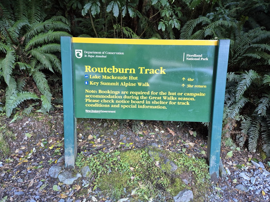
The Key Summit track is part of the Routeburn Trail. The hike to the summit and back should take about 3 hours as estimated by the Department of Conservation.
 First part of the trail to Key Summit is flat and relatively easy.
It was flat initially through shaded, mossy forest. Once out of the forest, the trail winds consistently uphill to the top.
 Up and up the many gentle switchbacks.
 Amazing views once we cleared the tree line.
 Views at the top of the Fiordland National Park are spectacular.
Once at the top, there is a short 20 minutes nature walk where we get sweeping 360-degrees perspective of the surrounding Humboldt and Darran Mountain Ranges. There are even tarns at the summit.
 Start of the 20 minutes nature walk at the summit.
 Doing the loop trail at the summit.
More about our hike to Key Summit, plus more photos, would be shared in a separate post.
It was about 5.40 PM when we completed our Key Summit hike. There was plenty of time left for us to return to Te Anau.
Eglinton Valley (again)
We made a stop at Eglinton Valley again to take in the vista. Eglinton Valley looked so different in the afternoon compared to what we had experienced on our way to Milford Sound in the early morn.

 Eglinton Valley in the late afternoon.
Eglinton Valley was the last stop on our return trip.
Overall, we had enjoyed our time at Milford Sound and the Fiordland National Park. We had the luck of good weather on this day and everything went according to plan.
By self-driving along the Milford Road instead of joining a tour, we managed to experience the spectacular scenery and attractions at our own time, without the crowds and also had the option to do some enjoyable walks and short hikes.


 Steamed green lipped mussels with classic creamy white wine & garlic sauce and garlic bread.
