16 March 2025

This is the day that we would drive from Fox Glacier to Wanaka. The 262 km journey should take about 3.5 hours without any stops but there are many attractions and sights to see along the way so it could take much longer. I had originally planned to do the following activities along the way:
- Do a short walk at Monro Beach where we may have a chance to spot penguins on the beach.
- Enjoy the views of the ocean at Knights Points Lookout and maybe spot some dolphins in the sea.
- Take a short walk at Ship Creek to feed some sandflies.
- View the waterfall at Thunder Creek Falls.
- View Fantail Falls.
- Stop at the Lake Wanaka Lookout for photos.
- Stop at the Lake Hawea Lookout for photos.
- Stop at the Lake Hawea Dam Lookout for photos.
With the activities during the journey, we would arrive at Wanaka in the evening. We had planned to hike up Roy’s Peak for sunrise the next day, departing early at 4 AM on Monday.
We had to ditch our plan due to rain forecasted at Wanaka on the day we were supposed to do the hike.

We decided to do a direct drive to Wanaka, timing to arrive at noon so that we could do the hike up to Roy’s Peak in the afternoon while the weather is still good. This meant that we only had time for brief stops at a FEW really nice places.
We left Rainforest Motel in Fox Glacier at first light. It was a good thing I had chosen to make full payment at check-in, so we could just leave the keys in the room upon check-out. We were probably the first car that departed the motel on this day.

Fox Glacier was like a ghost town early in the morning. Ours was the only car on the road.
We took the Coastal Highway 6 southwards. We passed through several one-lane bridges, very common on this stretch of the highway.


I love driving in the morning. There were lesser cars on the road and the morning light made the scenery more beautiful. We had to look out for cyclists though. We passed by a few groups of them.


It started raining as we drove through the coastal area. We passed by Knights Point Lookout and Ship Creek but did not make any stop. We probably did not missed much since the weather was not good.
We had brief views of a rainbow as we approached Haast.

After crossing the long one-lane bridge over the Haast River, we made a stop at the Haast Visitor Center. This place has excellent toilet facilities and information about what to do and see around Haast. Haast is also the place to top up petrol, if needed, before attempting to drive across the Haast Pass.

The 140 km stretch of road between Haast and Wanaka is known as the Haast Pass Highway. The road winds among steep mountains cloaked in lush rainforest and cross tumbling rivers. Clouds were seen overhead. Fortunately, there was no rain on this dangerous, narrow and curvy road.

We made a brief stop to view the Thunder Creek Falls and also to get a break from the driving. There are several waterfalls along the Haast Pass highway and this falls is probably the most impressive and accessible.

A few minutes away from Thunder Creeks Falls is the metal bridge over the Haast River, called the Gate of Haast. This is a good landmark on this drive but parking near the bridge is limited and also on the opposite side of the road.


We passed by several attractions such as Fantail Falls, Haast Pass Lookout (requires a hike) and Blue Pools (temporarily closed) but we chose not to stop.
The beautiful blue waters of Lake Wanaka soon came into view on our right side.

For the next 15 minutes or so, we were treated to beautiful views of the lake on our right as we travelled on the winding road that hugged the side of the mountain on our left.

There are a couple of lookout points along this stretch of Highway 6 but they were all located on the right side of the road. It was dangerous to access these lookout points so we just enjoyed the views from the car.
After passing through a stretch of land known as the Neck, we stopped at a lookout point (Google Maps location here) on our left. This lookout point provides nice views of Lake Hawea and the surrounding mountains.


The drive to Wanaka was so scenic that we took our time to appreciate the scenery. This is not so for the locals who are probably sick of the views by now.
There is another lookout point further down the highway, near the middle of Lake Hawea (Google Map Location here). The second Lake Hawea Lookout Point had just a small area by the road for several cars to park. We managed to squeeze our car into the space.
A path leads to the viewpoint just above the car park where we enjoyed views of the blue waters of Lake Hawea. If we had come on a rainy or cloudy day, the views may not be as good.


This was the last stop we made on our way to Wanaka. We were glad to note that the weather was perfect for our planned hike in the afternoon.
It was slightly past noon when we arrived at the town centre of Wanaka. During the drive, we did research and chose to eat at Gusto168, a Chinese restaurant.


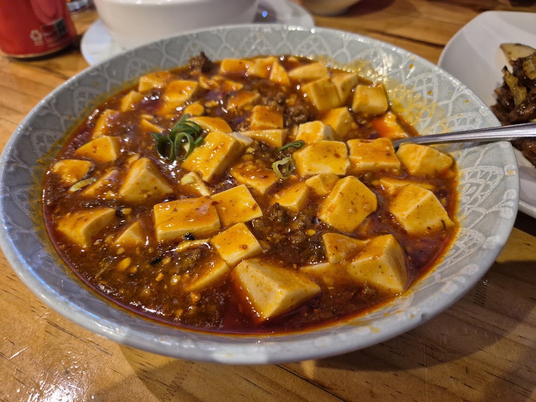
The food at Gusto was quite good but I felt that the prices were a bit too high. We were charged NZD 135 for the above food, 3 steamed rice and 3 cans of Coke.
By the time we finished lunch, it was 1 PM. Everything has gone according to our new plan. We even had time to check into our accommodation in Wanaka before starting our challenging hike up Roy’s Peak.
Next post: Overcoming the challenge we set ourselves by hiking up Roy’s Peak.
 Roy’s Peak Lookout with views of Lake Wanaka. Mount Aspiring and the surrounding mountains.
 The entrance to the track is located on the left of the car park’s entrance.
  View of the mountain we are about to climb. The end goal is somewhere up there!
  The start of the Roy’s Peak track. We need to climb a small ladder over a fence to officially start the trail.
 Initial part of the trail with steep incline.
 Our son taking one of the shortcuts. That was the one and only time he did that.
 Took a photo of us after taking the short-cut.
 After an hour on the track, we get to enjoy views like this.
 A rest after 1.5 hours of hiking. The views get better and better the higher we go.
 View of the lake and mountains after 1.5 hours from start.
  After about 2 hours into the hike, we are probably somewhere near the middle section of the trail.
 We could already feel a little sense of achievement when we saw the switchbacks we had taken to this point.
 Our destination is somewhere there!
 Almost there! We could see people at the Roy’s Peak Lookout.
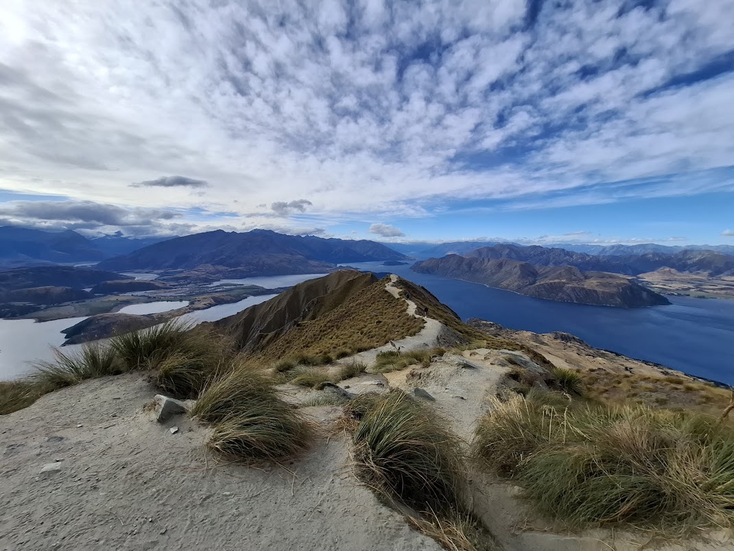 First photo of the Roy’s Peak Lookout. Many people would walk along the ridge to the end for photos.
 There is even a long drop toilet at the lookout point.
 Walking down to the Roy’s Peak Lookout.

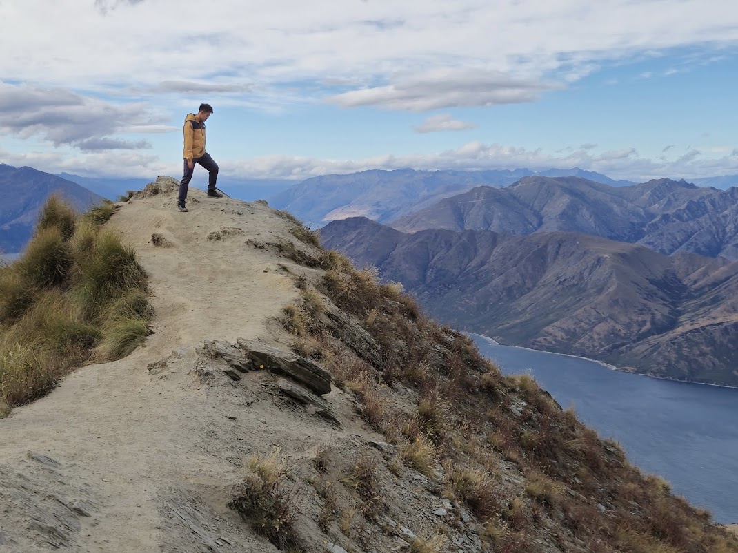


 My wife and I at the Roy’s Peak Lookout.
  These sheep on the trail moved away once we approached them.
 The journey down seemed to take forever.
  The cows giving a stare.
 The sky was a little cloudy, so we missed seeing a spectacular sunset.
 Reached the car park after a 2 hours 40 minutes journey down.
 Dinner was roast chicken and instant noodles back in our apartment. Comfort food after a day on the mountain.