9 November 2024
Sakurajima is one of Japan's most active volcanoes and the symbol of Kagoshima. Located in the middle of Kagoshima Bay (also known as Kinko Bay), Sakurajima is the area's most prominent geographic feature and was the main reason why we came to Kagoshima. Our plan for the day was to explore the sights on Sakurajima and areas around the bay before heading north to Kumamoto. Prior to taking the ferry across the bay to the volcano, I thought it is good we have a nice look at it from the Shiroyama Observatory where we could enjoy views of Sakurajima, the city and Kagoshima Bay.
The observatory is located on Shiroyama ("Castle Mountain"), a 107-meter hill located in the center of Kagoshima city. Its name comes from the fact that it was once the site of a castle. Besides being a nice green park in the middle of the bustling Kagoshima City, the park has many historical monuments, being the site of Battle of Shiroyama, the final battle of the Satsuma Rebellion, which took place on September 24, 1877.  View of Sakurajima, Kagoshima city and the bay from Shiroyama Observatory. The active volcano is about 4 km across the water from Kagoshima city.
From the car park, we took a nice stroll through the lush green park to the promenade where the observatory is located. Although it was an overcast day, the view of the majestic Sakurajima in Kagoshima bay with the city of Kagoshima in the foreground was really nice.
It is good that there are information boards that provided us with information on how Sakurajima and also how the Shiroyama tableland was formed.

A large volcanic eruption about 29,000 years ago created the Aira Caldera in the northern part of Kagoshima Bay. Massive amount of magma flowed out and covered large parts of southern Kyushu area where we stood. 3,000 years later, further volcanic activities give birth to Sakurajima as the volcanic island appeared from beneath the sea on the southern part of the Aira Caldera. Over time, more eruptions caused the volcano to rise further.
Sakurajima was a volcanic island in the bay until 1914 when a powerful eruption occurred. The island became physically connected to the Osumi Peninsula in the east as a result of massive lava flow created in that eruption. We would be seeing the effects of that eruption up close when we drive around Sakurajima later in the day.

Although Sakurajima is now connected to the mainland in the east, the volcano is still most easily accessed by the ferries from Kagoshima located on the western side. The Kagoshima municipal ferry runs every 15 to 20 minutes, 24 hours/day between Kagoshima Port and Sakurajima Port. One way trip takes approximately 15 minutes and bicycles and cars can be loaded.
From Shiroyama, it was a short 10 minutes drive to the Kagoshima ferry terminal. There was no need to pre-book the tickets. Payment is done at the Sakurajima terminal. For cars, there is a toll booth that collects the fees for the car and the passengers inside after driving off from the ferry.
 The Kagoshima municipal ferry runs every 15–20 minutes 24 hours/day between Kagoshima Port and Sakurajima Port.
Driving the car onto the ferry was easy. We just need to follow the directions provided by the road marshals.
Boarding and disembarking from the Kagoshima ferry.
After securing the car in the ferry, we were allowed to wander around the ferry, get some food and take some pictures. The stall in the ferry serves delicious udon that is quite popular with passengers.
We paid the fees for the ferry crossing at a toll gate after driving off the ferry. Since we are first time visitors to Sakurajima, we went to the Sakurajima Visitor Center first.
Sakurajima Visitor Center
The visitor center is worth a visit to understand more about volcanoes, Sakurajima’s history and how the locals lived so near to the volcano.
There is a short video about Sakurajima with English subtitles but we did not view the video since our timing was not right. Instead, we browsed through the interesting exhibits. Most of the explanatory texts are in Japanese but there are some English translations and we also had Google Translate on our phones.
 Pictures on the floor showing how Sakurajima was formed in the Kagoshima Bay through volcanic eruptions eons ago.
Sakurajima is a very active volcano. A chalkboard showed the number of eruptions and explosive eruptions over the past few years. An eruption is counted when the volcanic plume rose more than 1000 meters into the air. An explosive eruption is any eruption that produces an earthquake, a shock wave or any amount of volcanic ejecta. There are 34 such eruptions in 2024 to date. Average of almost 3 times a month!
 Chalkboard keeping score of the number of eruptions and explosive eruptions over the years.
 Despite the dangers, about 5,000 people lived on the island. When Sakurajima erupts, ejecta from a few millimeters to several centimeters can fall in populated areas. It often covers Kagoshima city in ash. Therefore, a helmet to protect the head is a necessity for the local school children walking to and from school. There are many shelters and evacuation centers in Kagoshima, and its residents are well-informed about precautions to take in case of an eruption.
 School children on Sakurajima are provided with protective helmets when they are at school or walking to and from school.
 Picture of a recent explosive eruption on Sakurajima.
 Model showing how Sakurajima became physically connected to the Osumi Peninsula in the east as a result of massive lava flow (orange colour section) created in the 1914 eruption.
The following series of photos were quite interesting. They showed the effects of volcanic eruptions and how the vegetation redeveloped over time.
 Barren landscape 30 years after the lava flowed over the land. Some green shoots appeared.
 Trees and other vegetation starting to grow out from the volcanic soil 50 years after the lava flowed over the land.
 Trees starting to become denser.
 Thick forest of trees about 200 years later.
The volcanic soil on Sakurajima is rich in nutrients. Farmers on the island produce the Sakurajima daikon radish which grows to enormous sizes and Sakurajima komikan orange.

There is a replica of the World Biggest White Radish grown in Sakurajima. The radish weighs 31.1 kg.
Overall, the visitor center is very educational and interesting and there is a very nice gift shop with souvenirs made from lava etc.
Sakurajima Volcanic Shore Park and Footbath
From the visitor center, we walked to the Volcanic Shore Park where there are plenty of longish footbaths next to the sea.
There were groups of students with their teachers at the park. These are probably visitors from other parts of Japan (since I did not see any yellow helmets in their school bags). Even with the school groups, there was plenty of space and footbaths for all of us.
 I sat next to some school girls as they are quieter compared to the boys.
It is nice to soak my feet while watching the ferries made the trips between Kagoshima and Sakurajima. We could also see Sakurajima, with its peak covered in clouds.
 Footbath at Sakurajima Volcanic Shore Park with the volcano in the background.
 The water in footbath was pretty hot, especially near the source of the hot spring.
We also went to check out the local FamilyMart and stores at the Hinoshima Megumikan Rest Stop.
This is a rather unique FamilyMart store. The signboard of this store was brown in color (instead of the usual white, blue and green) and the entrance had double doors. Apparently, the store is painted in a brown color scheme to match the volcanic landscape and the double doors are necessary to prevent volcanic ash from entering the store.
 Family Mart with a brown sign to match the scenery and double doors at the entrance.
The souvenir shop at the Hinoshima Megumikan Rest Stop has some interesting items and snacks based on local produce (radish and oranges) and very nice soft serve ice cream!
 Orange flavoured ice–cream based on Sakurajima’s komikan oranges.
 Giant radish growing outside the shop at the rest stop for visitors to view.
Yunohira Observation Deck
There are a few observation decks on Sakurajima where we could view the volcano. We went to the Yunohira Observation Deck first. This is the closest to the craters and it is also the highest viewpoint. A winding road that is wide enough for tour buses leads to the viewpoint.
From the car park, we walked up a flight of stairs to the viewpoint. We spotted a unique heart-shaped stone on the floor of the stairs. Apparently, there are a few of these stones for visitors to find.
 We spotted a heart shaped paving stone on the stairs leading up to the view point.
 View of the volcano’s peak from Yunohira Observation Deck.
There is a tower where we get 360 degrees panoramic views over lava fields, the wooded slopes of Sakurajima volcano and Kagoshima Bay.
Sakurajima is a volcano formed by the merger of two volcanoes, Kita-dake and Minami-dake. Only Kita-dake existed about 5,000 years ago. Minami-dake was created by an eruption about 4,500 years ago and Sakurajima had since taken on its present shape. Kita-dake is now dormant while Minami-dake crater is currently active and emitting smoke.
The mount's highest-peak rises to 1,117 meters and has a caldera with a circumference over 50 kilometers.

Information board with photos of the calderas of Kita-dake and Minami-dake, the twin volcanoes on Sakurajima.
The peak was shrouded by low clouds during our visit, so the calderas were not visible. Anyway, we were too low to have nice views of the calderas. Sakurajima is too active and dangerous to get close to.
 The area around the crater is covered by lava while the areas further away have lush vegetation.
 View of Kagoshima city beyond the waters.
Arimura Lava Observation Deck
The Arimura Lava Observation Deck was the next place we visited. It is located about 20 minutes by car from Sakurajima Ferry Terminal Sakurajima Port along Route 224.
Here, we could see Sakurajima from a further viewpoint. It is located on a small hill in the lava field created by the great 1946 eruption. This place has some interesting formations of lava rocks.
 View of the Sakurajima from Arimura Lava Observation Deck.
 One of the lava rock formations displayed at the Arimura Lava Observation Deck.
 This lava rock formation looked like a sitting lion?
 Visitors stuck coins into the lava rock for some strange reason.
 Walking path with some shelters along the way.
Besides the lava rock formation, there was not much to see at this place. There are a couple of souvenir shops next to the car park. We bought a small bag of Sakurajima komikan oranges to try. The small mandarin oranges has a thin peel, juicy but not sweet and came with seeds.
Kurokami Buried Shrine Gate
Our last stop on Sakurajima was more interesting. We had to take a short detour from Route 224 to get to the Kurokami Buried Shrine Gate.
 Kurokami Buried Shrine Gate.
This was the remains of a torii gate from a landmark shrine buried by the huge volcanic eruption in 1914 that linked Sakurajima Island to the mainland.
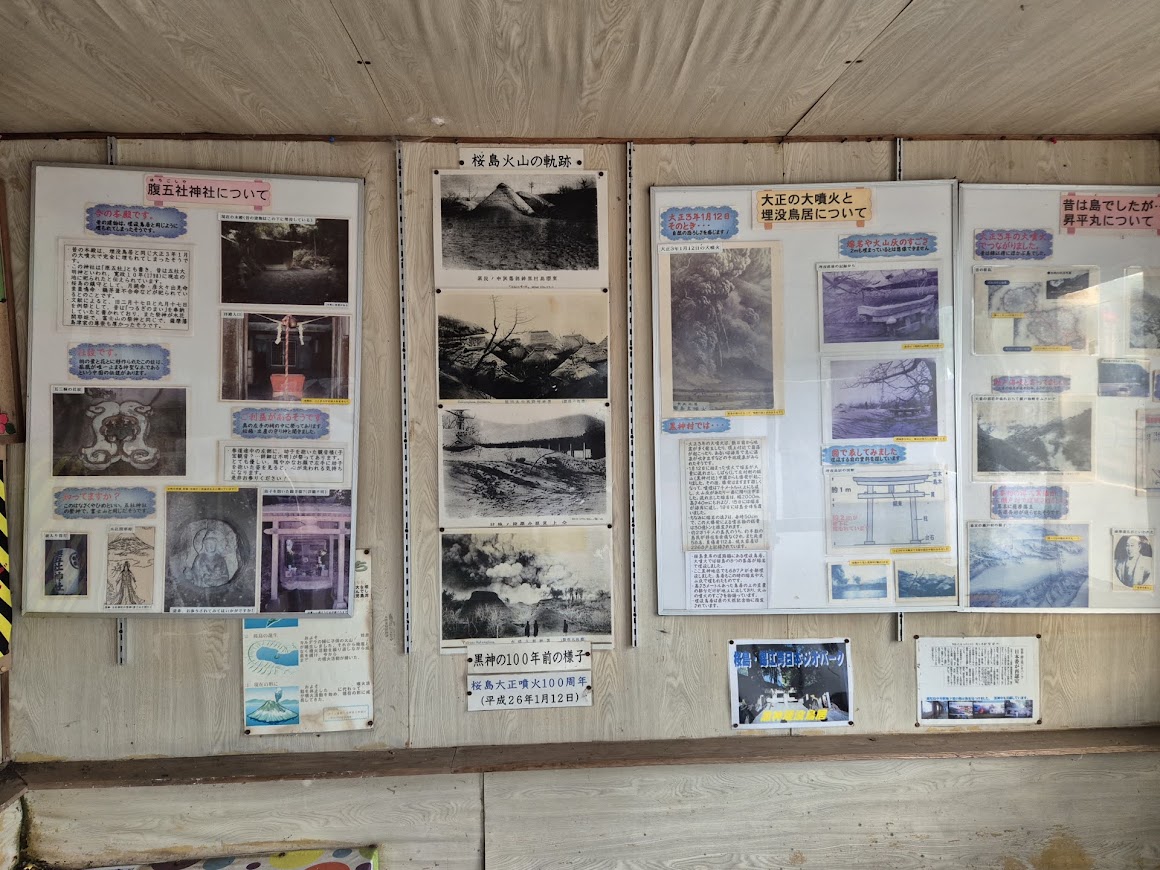
 Information board explaining what happened on the 1914 eruption.
It was interesting to read the information board at this place. People knew the 1914 eruption was imminent when the wells on the island started boiling, shoals of dead fish floated ashore and the earth shook intermittently 3 days before that fateful day on January 12, 1914. It is good to know that volcanoes do not suddenly have a massive eruption without giving some early warning signs.
On the day of the eruption, thick black smoke rose 7,000 meters into the sky and covered the whole island. Lava started flowing and 3 billion tons of red hot lava flowed across the sea at this place and welded the island to the mainland.
At Kurokami, 687 houses were buried in hot ash. Only the top beam of the 3 meters high torii gate could be seen now. We estimated that the hot ash was as least 2 meters deep. It is good that the gate is preserved to let future generations appreciate the fury of the eruptions.
 Pictures and stories of what happened could be seen inside a small hut next to the buried gate.
 This was what remains of a 3 m high torii gate to the Haragosha Shrine.
Learning from great eruptions of the past, the communities living on Sakurajima have built numerous evacuation shelters. Its residents are well-informed about precautions to take in case of an eruption. 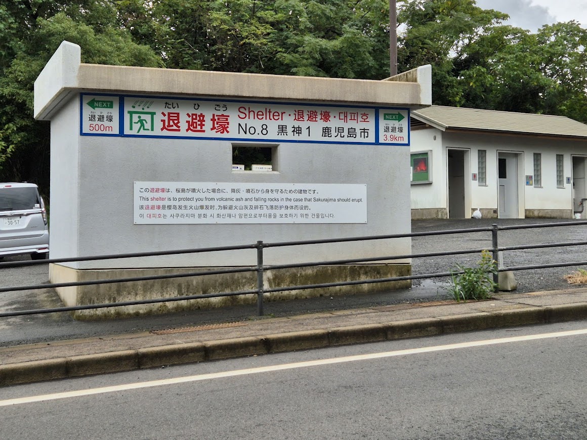 A volcanic shelter could be seen across the road from the buried gate.
We left Sakurajima by driving across the Ushineo Bridge located on the eastern side. The views from the arched bridge were quite nice. We could see fishing boats and fishing villages below us.

On the national road 220 leading us out from Sakurajima via Ushineo Bridge.
After crossing the bridge, we headed northwards on National Road 220 running along the eastern shores of Kagoshima Bay.
Tarumizu Yuttarikan Roadside Station
The Tarumizu Yuttarikan Roadside Station (Google Maps location here) is a good place to stop for a rest. This is a good place to see Sakurajima with the sea in front.
 View of Sakurajima with white gases and steam rising from its crater.
By now, the clouds over the volcano had cleared and we could see white gases and steam rising from its crater. Compared to the Mount Aso’s Nakadake volcano we saw a few days earlier, Sakurajima had lesser emission on this day. Nevertheless, it was still a thrill, watching the very active volcano spewing gases from just a few kilometers away.
 The best place to view the Sakurajima volcano is not on Sakurajima but along the shores of Kagoshima Bay.
Besides views of the volcano by the sea, there are shops, restaurant and hot spring with footbaths at this rest stop. There is also a large green field with playground equipment for kids to enjoy and a ship monument.
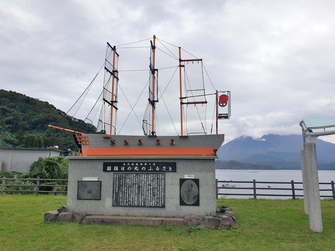 The ship monument at the Tarumizu Yuttarikan Roadside Station.
Although there is a restaurant at the roadside station, we did not have our lunch there. I had plan to eat at the Chinese restaurant located at the Sakamoto Kurozu Brewery located just a short drive down the highway (location here).
Sakamoto Kurozu (Black Vinegar) Brewery
The brewery is located off the highway. It was easy to locate since there are red colour signs pointing the way to the brewery, in addition to the directions given by Google Maps.
We parked our car next to the Information Center where the restaurant is located. Sakamoto made black vinegar the traditional way using jars. The information center had pictures explaining the production process with Japanese text. The vinegar was named "kurozu" (black vinegar) because of the characteristics of vinegar produced in jars, which is that it is darker in color than regular vinegar. The vinegar gets darker the longer it is aged in a jar.
 Rows of jars with vinegar fermenting inside could be seen from the restaurant.
The restaurant serves Chinese food with kurozu as an ingredient or food that is best eaten with it. We were shown the English set lunch menu. The set lunch includes a glass of aperitif vinegar, assortment of 3 types of appetizers, main course, salad, rice and soup for a reasonable price of 1650 Yen (tax included). There are three options for the main course - sweet and sour pork, shrimp with chili sauce, or spicy stir-fried chicken.
 A glass of apple flavoured aperitif vinegar, assortment of 3 types of appetizers.
 Main course of sweet and sour pork, rice, salad and soup.
The sweet and sour pork is made with kurozu and is very delicious when eaten with the steamed white rice. The starchy egg soup is to be eaten with a dash of black vinegar and pepper that were provided on the dining table.
 Great place to drop at and grab lunch with stunning view of Sakurajima.
 Sakamoto Kurozu (Black Vinegar) Brewery was the last place we visited along Kagoshima Bay.
Although I had planned to see some minor attractions in the town of Aira located at the northern part of Kagoshima Bay, we had to skip them since we wanted to see Sogi Falls and drive to Kumamoto before sunset.
Sogi Falls, also known as Sogi no Taki, is one of the largest and most beautiful waterfalls in Japan and worth a visit.
Next post: Sogi Falls.


