21 March 2025

In this post, I will be sharing the places we stopped at, what we did and eat along the way. This includes watching the bungee jumpers at Kawarau Gorge Suspension Bridge, wine tasting at Kinross Winery, Cromwell, Lindis Pass, lunch at High Country Salmon and stopping at scenic viewpoints along the Mount Cook Road.
We left St James Apartment, our accommodation in Queenstown promptly at 8.30 AM and ran into peak hour traffic for a bit. Once we passed Frankton, the traffic on State Highway 6 became lighter and we made good progress to arrive at our first stop for the day as planned.
Kawarau Gorge Suspension Bridge
The Kawarau Gorge Suspension Bridge is where the Kawarau Bungy Centre is located.

For those new to bungy (also spelled as bungee) jumping, this activity is where you leap from a high place while secured by a long nylon-cased rubber band around the ankles. At the Kawarau Bungy Center, jumpers get to jump from the middle of the Kawarau Gorge Suspension Bridge and free-fall about 43 meters towards the river below.


We walked through the Kawarau Bungy Centre to get a feel of the prices. It will cost NZ$320 for a jump off the bridge and NZD50 for a ride on the zip-line. With my fear of heights, I will never attempt bungy jumping even if they pay me big bucks to do this.
We walked to the viewing platform to watch the thrill-seekers do their jumps. I believe the bungee operator will weigh the jumper and asked if you want to touch the water below. They would then adjust the length of the bungy cord accordingly.


We also watched 2 ladies riding the zip-lines down the river.

Wine tasting at Kinross Winery
The Gibbston area that we were driving through is home to some of the world’s best Pinot Noir and other impressive white wines. Situated along the spectacular Kawarau Gorge, Gibbston is home to a few renowned vineyards that offer wine tasting for visitors. I had planned to stop at one of the vineyards for wine tasting experience and chose to visit Kinross Winery.
This winery has a cellar door that offered wine tasting from a few neighbouring vineyards (Hawkshead, High Garden, Valli, and Wild Irishman) in addition to their own Kinross wines.


For wine lovers and enthusiasts alike, Kinross offers in-depth wine experiences to showcase exceptional Central Otago wines along with tales of this industrious and proud wine region. We chose to do the classic wine tasting of 5 wines for NZ$25 per person. I had done online booking of the tasting for 10 AM at their website a few days earlier.

 The wines that we tasted. Kinross Holy Schist Sauvignon Blanc 2024, Hawkshead 2024 Pinot Gris, Valli 2022 Pinot Noir and Wild Irishman 2023 Pinot Noir from Central Otago and Pinot Noir 2024 from Bannockburn.
Besides our group, there is also a couple from the US. We had the most amazing wine tasting experience with Francesco, our wine advisor. He told us stories of the people behind the wines, how the climate and soil made the wines in this region so unique. The wines are mostly consumed within the country due to limited quantities.
The wines that we tasted were all good and the amount of wine in each pour was quite generous. At the end of the tasting, Francesco asked each of us to rate each wine that we tasted.
Unanimous favourite was the Kinross “Holy Shist” Sauvignon Blanc, followed by Valli Pinot Noir 2022. We then learn the prices of the wine – Kinross Holy Schist was NZ$45/bottle and the Valli was NZ$85/bottle. The Wild Irishman wine was most expensive at NZ$ 99 per bottle and has a bolder taste that some may prefer.
We bought 2 bottles of the Kinross and 1 bottle of the Valli wine to bring home.
As we were walking back to our car, we spotted an area where there was a tripod mounted on top of a wine barrel, just nice for a photo-shoot with beautiful backdrop.

Cromwell
From the Gibbston area, we continued our drive along Highway 6 to Cromwell.
Located on the shores of Lake Dunstan, Cromwell has the appearance of a modern town, but its history stretches back to the gold rush days of the 1800s. This history is best experienced in “Cromwell Heritage Precinct”, a feature attraction for visitors.


Visiting the Heritage Precinct was like a step back in time. We could see old historic buildings dating back to the gold rush of the 1860’s. These buildings had been repurposed into artisan shops, cozy cafés, and galleries.

Compared to Arrowtown, this place is just a single, very small street. However, the view of the blue water of the Clutha River was so nice.

We saw a local dog swimming in the river, fetching a stick that its owner had thrown in.


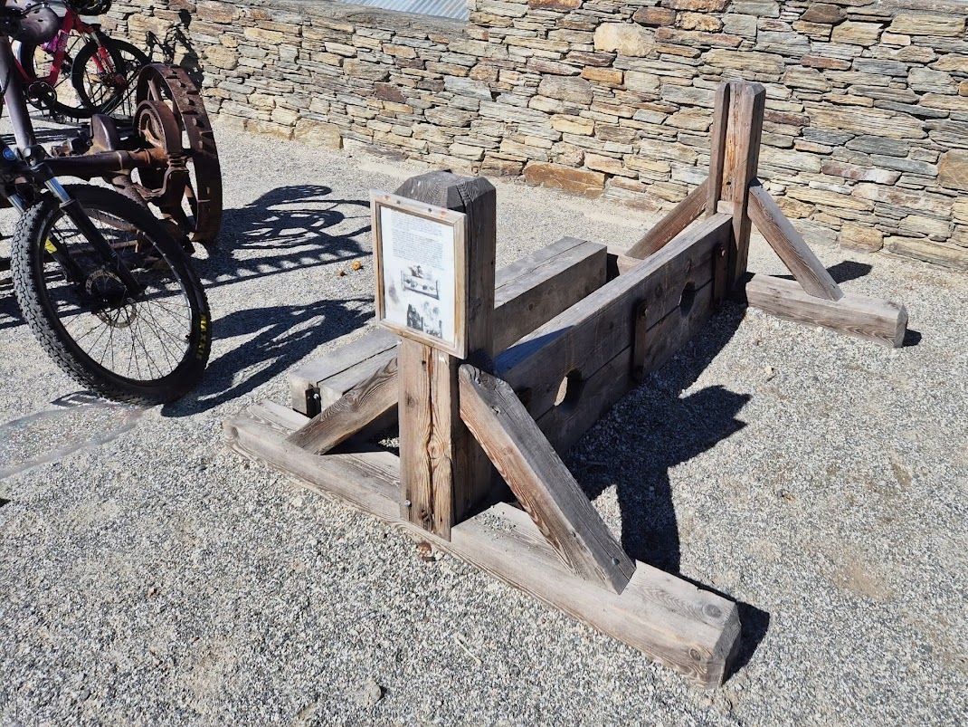 The naughty and drunk would be chained to this in the old days.
We bought some coffee and pie from the cafe located inside the Grain and Seed store. This store resells excellent pies from Cromwell’s popular Sanga Pie store.


After our short visit to Cromwell, we took State Highway 8 northwards towards Twizel. The drive along the eastern shore of Lake Dunston was very scenic. We did not stop for photos but my wife managed to take some nice photos of the scenery from the car.

After passing Lake Dunston, there was not much to see except farmland, grassland and small forests until we arrived at Lindis Pass.
Drive through Lindis Pass
The drive through Lindis Pass was like our drive through the Crown Range Road, except that this is much less scary. We saw plenty of brown coloured mountains and winding roadway.


Lindis Pass Viewpoint is located at the highest point along Lindis Pass. This lookout is at 971 metres above sea level. Unfortunately, it is on the other side of the highway, making it extremely dangerous for us (going towards Twizel) to make a stop. So, we gave it a miss.
Note: In fact, the road is marked with double yellow lines in the middle which makes it illegal to get to the car park of the Lindis Pass Viewpoint if you are travelling northwards.
Stop at High Country Salmon for lunch
High Country Salmon is a salmon farm cum shop and cafe located along State Highway 8 towards Twizel. This is a good place to stop for lunch if you like fresh salmon sashimi and outdoor dining.
Since we like fresh salmon and the novelty of outdoor dining with nice scenery, we chose to stop here for lunch instead of driving a further 10 minutes into the town of Twizel.

Visitors to High Country Salmon are able to have a meal at the floating cafe and take in the idyllic scenery. The cafe has a good selection of food including sashimi and sushi, as well as an all-day a la carte menu, a selection of alcoholic and non-alcoholic drinks and fantastic coffee.
We had the option to sit indoors or sit outdoor on the floating platform. We ordered and pay for the food inside the cafe and the service staff delivered our drinks and hot food to our table on the floating platform.

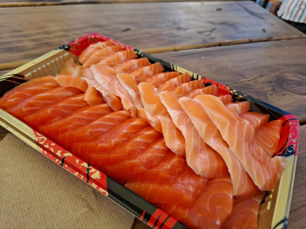


The salmon farmed here are the Chinook Salmon, also commonly known as King Salmon. They are hatched in late May and grown at the hatchery for 6 months. They are trucked to the farm in November at around 30 grams average weight. They then spend anywhere from 17- 27 months in the farm here until they reach the harvest weight of 3 to 5 kg.

After lunch we went to take a look inside the Fish Shop & Deli. They offer a wide range of salmon products for customers to take home. This includes fresh, smoked or cured salmon in a variety of cuts.
After lunch we drove pass the town of Twizel. There is no gas station and grocery store inside Mount Cook National Park. Hence, Twizel is a good place to top up petrol and buy groceries before heading to Mount Cook Village.
Mount Cook Road
The drive from Twizel to Mount Cook Village, following State Highway 80 (Mount Cook Road), offers breathtaking views of Lake Pukaki and the surrounding mountains, including Mount Cook itself.

Driving on the Mount Cook Road with Lake Pukaki on our right side.
On a sunny day, Lake Pukaki could be New Zealand's bluest lake. It also shows off New Zealand's tallest peak, Aoraki/ Mount Cook, from the many lookout points around its shores.

One of the best places to stop along Mount Cook Road is at Peter’s Lookout. Google Map location here. There are ample parking spaces and also toilets.


The drive along Mount Cook Road is one of the most scenic and enjoyable. You feel like stopping again and again to snap photos as after every turn, the view gets better and better.
We did not make many stops. Instead, I took photos through the windscreen of the car as my son drove slowly towards Mount Cook Village.


Hermitage Hotel at Mount Cook Village
We arrived at Mount Cook Village at about 4 PM. This is the best place to stay when visiting Mount Cook National Park but hotels are limited. Those who could not get accommodation here may have to stay at Twizel (30 minutes drive away).
The Hermitage Hotel offers a variety of room types. The Premium Rooms located in the Aoraki Wing and the Superior Rooms located in the Wakefield Wing will have the best views of Mount Cook and the surrounding mountains. The Standard Rooms located in the Mount Cook Wing may not have the best views but they are closer to the main entrance, reception, restaurants and the Sir Edmund Hillary Alpine Centre.
Sir Edmund Hillary, a New Zealand mountaineer, and Sherpa mountaineer Tenzing Norgay were the first climbers that summited Mount Everest. Edmund Hillary honed his climbing skills and achieved significant first ascents on Aoraki/Mount Cook in New Zealand. The Sir Edmund Hillary Centre is a museum showcasing the history of the Mount Cook region with transport, climbing and Sir Edmund Hillary exhibits.
This hotel, although most expensive in the area, is often fully booked. I was fortunate to be able to secure a Superior Room with fantastic views of Mount Cook from their hotel’s website.


We could see cars and campervans travelling to the White Horse Hill campground and car park in the distance. This place is the start point of the famous Hooker Valley hiking trail in Mount Cook National Park.
We had time to do a short evening hike at Hooker Valley Track before sunset which was 7.50 PM at this time of year.