14 March 2025

We started our road trip around the South Island of New Zealand with a coast to coast drive from Christchurch to Hokitika via the Great Alpine Highway. The 230 km journey would take us through amazingly scenic landscapes and offers plenty to do along the way.
We left Airport Birches Hotel at about 8.30 AM. The route from our hotel in Christchurch follows State Highway 73 west across river plains before ascending to traverse Porters Pass and Arthur’s Pass National Park. The total driving time without any stops is about 3 and a half hours, so we had plenty of time to explore various sights and natural wonders along the way.
The first part of the drive on Highway 73 through the Canterbury Plains was relatively easy, with straight roads through farmlands and suburban towns and views of the Southern Alps in the horizon.

World Famous Sheffield Pies
We made a deliberate stop at the small town of Sheffield. We cannot come to New Zealand and not eat their meat pies. The first pies we bought in this trip were from a bakery in Sheffield called the World Famous Sheffield Pies. This little bakery shop is highly recommended by people driving to and from Arthur’s Pass.
There are ample parking spaces behind the shop. Despite a sign informing customers where to queue for the pies, there was no queue since we were early. The shop had a great selection of pies displayed behind the glass cabinet and all looked very good.


We bought 3 different types of meat pies and an iced coffee for takeaway since we just had a nice breakfast less than an hour ago.
Our choices were:
- Sheffield Supreme Pie stuffed with steak, bacon, cheese and onion.
- Country Chicken with chicken, bacon and mushroom.
- Steak and cheese pie.
Homer’s Donut in Springfield
We made a quick stop at the next small town along State Highway 73, just to snap photos of a pink coloured donut complete with sprinkles on it. Springfield shares the same name as the fictional town where the cartoon characters in The Simpsons cartoon live.
The Simpsons cartoon has been around for more than 30 years. On 27 July 2007, The Simpsons Movie premiered across the globe and 20th Century Fox presented a giant pink donut to the town of Springfield in NZ to promote this movie.
The original donut was destroyed by fire in 2009 and the current donut was a new one installed in 2012. The sculpture looks identical to Homer Simpson's favorite snack.

Homer’s Donut is located in a field right next to the highway, so it was quick and easy to make a stop just for some photo fun.
Leaving Springfield, we headed westward and drove through some farmlands in the plains.

We spotted mist ahead but our concerns for bad weather soon cleared up, just like the sky above us. New Zealand's weather is known for being unpredictable, with locals often joking that you can experience "four seasons in one day" due to its rapid and frequent changes.
Porter’s Pass
We ascended the winding mountain road from the mist on the Canterbury Plains through Porter’s Pass to clear skies above the mountain range.
There were some heavy vehicles chugging along up the slope, so we had to go slow. It is good that the authorities had build in some passing lanes into the highway at regular intervals for faster vehicles to overtake safely.
We made a stop at the Porter’s Pass Lookout which was located on the right side of the highway. The space was large enough for several cars but we were the only car that made a stop.

The view from the lookout was magnificent. We could see the winding road that we had taken through the mountain range.

The large vehicles that we had overtaken earlier soon pass by. When we continued our drive downhill, it was strange that we never see those vehicles again. They must have gone at a faster speed when descending.
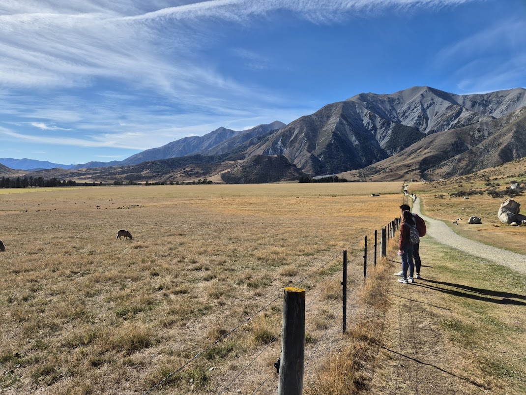
Castle Hill (Kura Tāwhiti)
Castle Hill, also known as Kura Tawhiti by the indigenous Maori Tribe Ngai Tahu, is one of the most popular stops on the scenic Arthur’s Pass drive.
Even from the highway, we could see many large boulders and rock formations strewn on a hill to our left. These looked like ruins from old medieval castles on a hilltop, hence giving the place its modern name. Large signs pointed us to a large car park on our left, so it is almost impossible to miss this attraction.
From the car park, there is a clear, open, and marked 1.4 km track to access the rock formations and boulders.

There were sculptures erected near the entrance. There is an informative sign here as well educating visitors about the ancestors connected to the land.
On the right of the access track was a vast field with grazing sheep.


With a little imagination we could give meanings to various rock formations. A set of stones known as Croaker Rock looked like a pair of mating frogs.

Further on, I saw a set of rocks that looked like a Mom with her left arm raised, disciplining a child with head bowed while the silent Dad looks on.

The set of rocks reminded me of our recent trip to the Stone Forest of Yunnan. Like the stone forest of Yunnan, these rocks were under the sea 30 millions of years ago. The limestone rocks were formed from shells accumulated on the seafloor and then compressed over many years. The collisions of tectonic plates (NZ is on a fault line!) pushed these mountain ranges up and exposed the limestone rocks.

Water eroded the limestone into the rock formations seen today. Castle Hill itself sits at about 700 meters above sea level.
Castle Hill is a photographer’s dreamland. We are free to wander off the marked trail to snap photos amongst and on top of the rocks. We took our time to explore the area, snapping some photos and climbing to the top of some of the boulders to get some unique angles and views.


On our way back to car park, we stopped to view and photograph the grazing sheep. For city folks, these are rare photographic opportunities.

Although there are public toilets at the car park, there was a long queue of people waiting. Several tour buses just pulled up.
My son needed to use the toilet urgently. We decided to drive a few minutes down Highway 73 to Castle Hill Community Hall where there are much better toilet facilities with flushing WC and basin with tap water. The toilets at Castle Hill car park are long drop toilets with no tap water.
We chatted briefly with a friendly staff at the Community Hall who was with a librarian. In the small township of Castle Hill, there is a mobile library that visits the community on a regular basis. They offered a good collection of very new books that the locals could borrow.

A few picnic benches sited next to the
Castle Hill Community Hall was an ideal place to have our picnic lunch. We ate the World Famous Sheffield Pies with hot drinks that we brought along.


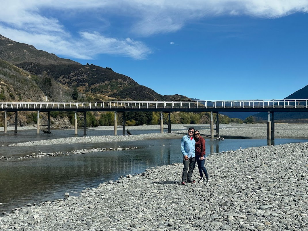
Mount White Bridge
Leaving Castle Hill, I was undecided whether to make a slight detour from Highway 73 to go take a look at Mount White Bridge (Google Map location here). I was glad we did.
Leaving Highway 73, we drove on an unsealed gravel road for a few minutes before getting a view of a bridge across the Waimakariri River.
The NZ TranzAlpine Scenic Train passed through this place and this is one of the scenic views that the passengers would enjoy. We had to drive across the railway tracks just before crossing the river on the single lane Mount White Bridge. The bridge is painted white in colour but I am not sure if this is due to its name.
What is so nice about a white colour bridge?


The campervan stopped beside our car. Its occupants came down for a short while, took some photos and then drove back across the bridge, leaving us alone at this place.

We took our time to enjoy this remote and beautiful place. It could easily be chosen as one of the filming locations for the movie Lord of the Rings but it is not.


Arthur's Pass Scenic Lookout
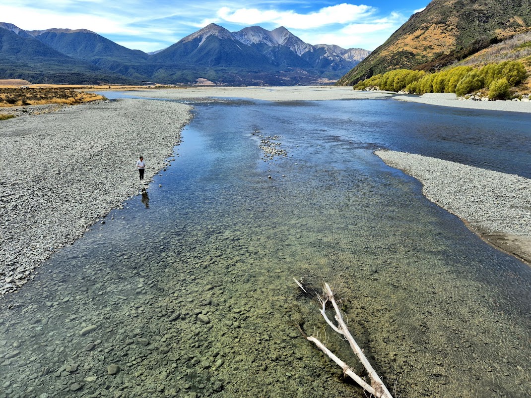
We drove back to Highway 73 to continue our journey to Arthur’s Pass. We had to cross a very long single lane bridge across the Waimakariri River again before stopping at the Arthur's Pass Scenic Lookout. The car park is located on the left side, just after crossing the bridge.
This is the gateway to Arthur’s Pass National Park and is worth a stop. There is a stone signage with good views of the river and mountains beyond.


Arthur's Pass, climbing to more than 900 metres above sea level through Arthur's Pass National Park, is the highest and most spectacular pass across the Southern Alps. There are many peaks over 2000 metres high with deep and steep sided valleys that has the U-shaped profile typical of glacial action.
It is named after Sir Arthur Dudley Dobson who found a route, originally used by Maori hunting parties, across the Southern Alps.
We did not stopped at the Arthur’s Pass Village which had a train station for the TranzAlpine Railway, post office, visitor centre, petrol station, tea rooms, restaurant and a few accommodations. We drove straight to the car park near Devil’s Punchbowl Falls located a few hundred meters after the village. There are several walking trails around Arthur’s Pass Village and we had chosen to do the hike to Devil’s Punchbowl Falls.
Hike to Devil’s Punchbowl Falls
The trail is about 2 km return and is an “out and back” trail. According to the signage, it should take about 45 minutes to complete.
Shortly after starting the hike, we could see the waterfall in the distance, through the trees. For those who did not want to hike to get a closer view, they could turn back at this viewpoint.

We next crossed the footbridge on the Bealey River.


We then entered a lush beech forest before climbing up a series of steps to a viewing platform at the base of the spectacular 131 m tall waterfall. There are about 300 steps to negotiate. This served as a good warm-up/training for us before we attempt the more challenging hike up to Roy’s Peak in a few days time.


Otira Viaduct lookout
Leaving Arthur’s Pass Village, we made 2 brief stops at lookout points to view some engineering marvels that made traversing Arthur’s Pass safer and easier.
The first lookout point, known as the Otira Viaduct Lookout, is located on the right side of the highway. There is a proper turnoff lane into a small road leading up to the lookout point.
The Otira Viaduct lookout offers nice views of the viaduct built across Otira Gorge. We would be driving across the viaduct later.
The alpine parrot Kea is known to frequent this place but no Kea was spotted during our short visit.

The second lookout point, known as the Otira Rock Shelter Lookout, is located on the left of the highway just after we crossed the Otira Viaduct.

We could see how the rock shelter has literally sheltered the road from rockslides. There is even a chute for water from a waterfall to fall beyond the highway.

This stretch of narrow and curvy road through the gorge has to be driven with care. After negotiating the winding road down the mountain to Otira, we stopped opposite the Otira Stagecoach Hotel for my son to take over the driving. This hotel has an interesting figure of Gollum/Sméagol , (a character from the Lord of the Rings movie) perched on the roof.

On hindsight, we should have gone into the hotel for a coffee break or a meal. I had read that this quirky hotel has a nice museum full of collectibles and antiques.
Leaving Otira, it was an easy and scenic drive down to the West Coast of the South Island.
Highway 73 ends at the roundabout known as the Kumara Junction. From there, we took the Coastal Highway 6 towards Hokitika.
On the way into Hokitika Town, we made a stop at the Hokitika Glowworm Dell. This is the place to see the famous glowworms of New Zealand for free. There is nothing to see in the day, except a signage to explain what is a glowworm.
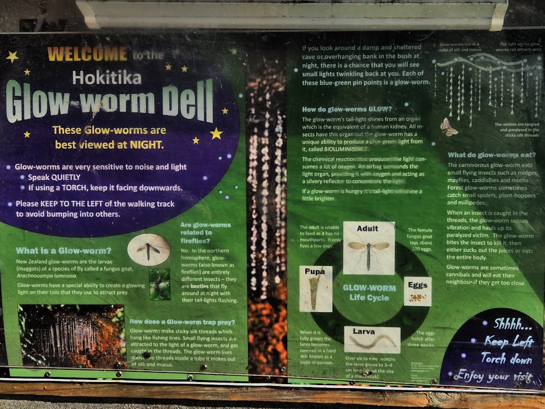
We planned to return after dark to see the glowworms later. It was good to stop to recce the place so we know what to expect.

Hokitika
Hokitika is a good place to stay for a night before continuing our road trip down the West Coast of the South Island towards the glacier towns of Fox and Franz Josef.
We reached our accommodation at about 4 PM. The check in process at Amberlea Cottages was simple and fast. We had been given the pin number for the electronic door lock and we just need to let ourselves in.


Historically, Hokitika started as a settlement and port in support of 1860s gold rush. Today, it is a tourist town with galleries specializing in greenstone jewellery and art. Visitors also could do a hike at Hokitika Gorge (which we plan to do the next day) and also enjoy the beach which is especially nice at sunset.