17 August 2022
This was our first morning at Tubkaek Beach and it was drizzling a little while we enjoyed the splendid breakfast at the Amari Vogue Krabi Resort.
After breakfast, the sun came out and this allowed my son and I to proceed with our plan to hike up Dragon Crest Mountain, while my wife enjoys the facilities at the resort.
Besides the beach, one of the must do when staying at the Tubkaek Beach area is hiking. Dragon Crest Mountain has one of the most beautiful viewpoints in the south of Thailand.
Dragon Crest (known by the locals as Khao Ngon Nak) is one of the most famous viewpoints in Krabi, offering really spectacular views of Krabi and its surrounding islands.
Besides the view, climbing Dragon Crest is one of the things my son wanted to do to help him prepare for his Mount Kinabalu climb later in September this year. The mountain is 565 meters above sea level and offers a tough 4.7 km hike to the top.
One good thing about staying at a hotel along TubKaek Beach is that we could walk to the start point of the hiking trail within 10 minutes. The Khao Ngon-Nak Nature Trail is located within a small National Park at the end of Tubkaek Beach.
Every person attempting the climb will have to register their name, vehicle number, mobile phone number, country of origin, time of entrance and exit with the park rangers. We were also to note down the phone numbers of the rangers in case of emergencies.
While signing the registry, I noticed that we were the fourth group on this morning. There were a group of Thais, Scots and Dutch before us.
| Entrance to the park used to be free of charge but this time round, visitors have to pay a 200 Baht National Park fee per person in cash. So don’t forget to bring some cash! |

Father and son at the start of the trail at 9.45 AM. My son volunteered to carry our daypack.
It is also a good idea to take a photo of the trail map to help us keep track of our progress during the climb. From the map, it is supposed to be a 4.7 km distance to the peak, with a first viewpoint at the 2.5 km park and another at the 3.5 km mark.

The weather was sunny after the morning drizzle but the air in the lush forest at the foot of the Dragon Crest mountain was fresh and cool.

The first part of the walk was easy with only a slight gradient. Although the ground was wet from the rain, it was not muddy as the soil on the track is actually sandy and porous. We had to be careful of the wet rocks though. Some could be slippery when wet.
About 500m into the hike, the trail became steeper and steeper., and the hike became tougher.

Good hiking shoes are essential although we were overtaken by a later group, with the guy wearing flip flops!

I was soon panting and perspiring like an ice cold bucket in the humid forest. We had brought only half a liter of water for each person. This was a mistake as we were perspiring much more than usual.
I was also pleasantly surprised by the lack of mosquitoes or other biting insects. In fact, we did not spot any wildlife, except for the noise from the cicadas and insects that produces what sounded like a buzzing chainsaw.
After about 35 minutes and somewhere near the 2 km mark, we came to the first set of wooden stairs.

Recently uprooted tree at the bottom of the wooden stairs.

The first section with 63 steps.
There were more uphill sections before we came to the second set of wooden stairs. The bottom section of the stairs were damaged but still accessible.

Second sections of the stairs.
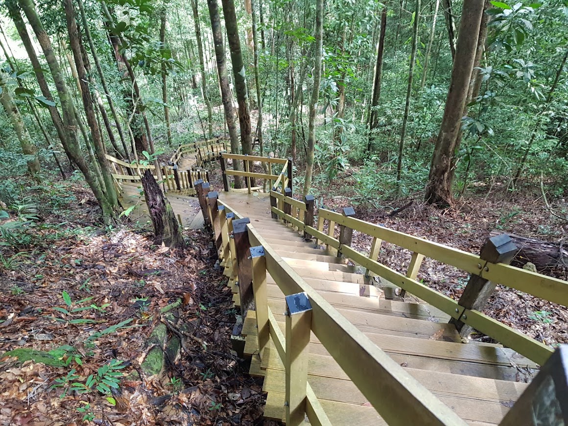
I counted 112 steps, excluding those that had fallen.
Some parts of the trails are basically rocks and tree roots forming “steps”.

There are of ropes to help us at the steeper parts.


The view from the first viewpoint.
The trail became less steep after this point.

Interesting signboard up in the mountain – call 1192 for Lost Car?
We saw some trees with reddish trunks. A signage describes this as the auburn zone, because of the colours of the trees’ bark.

We seemed to be walking on a ridge and could feel cool breeze through the trees.

We arrived at the Khao Ngon Nak Scenic point at about 11.50 AM. It has taken us about 2 hours to get to this point.


Khao Ngon Nak Scenic viewpoint.

Getting some energy replenished. But by now, I was running low on water.
But this viewpoint is still not the peak of the Dragon Crest mountain. Continuing on the trail to the right of the viewpoint, there is a steep trail up some rocks.


Getting up to the peak requiring scrambling up this set of rocks.
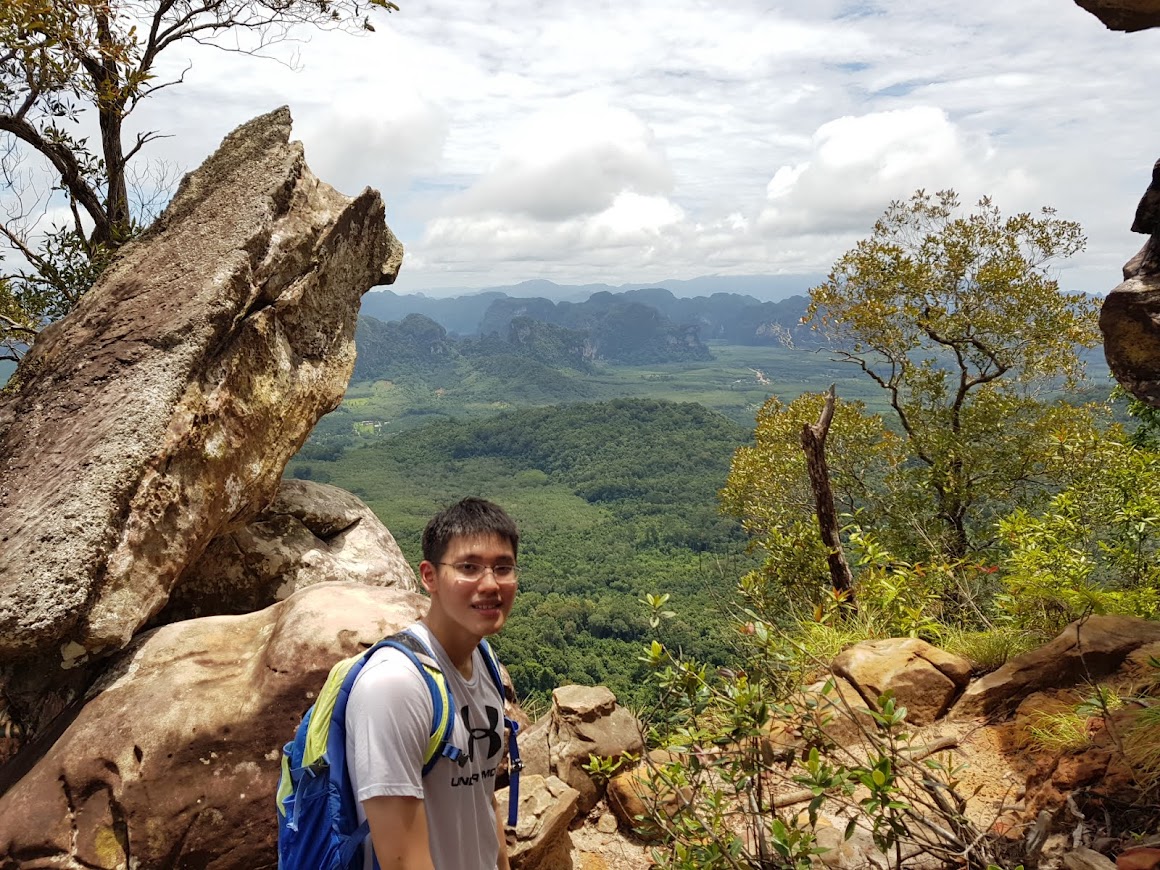
About 15 minutes later, we arrived at what seems to be the peak.
We took time to explore the area and there are a few rocks and ledges offering different vantage points of the surrounding countryside.

We found a nice huge rock that overlooks the coast. We could see the Railay Peninsula, Ao Nang Beach, Nopparat Tharat Beach and the offshore islands (namely Tub, Poda and Chicken Island).

There was rain forecasted in the afternoon. We could see some dark storm clouds approaching in the distant as we started on our return trip.
Getting down the steep mountain trail was easier on our lungs but took a toll on my aging knees.
We met a few more groups of hikers making their way up despite the imminent storm.
The sky finally burst when we were about 500 meters from our end point. Thunder clapped above us and I was keeping a lookout for falling branches or trees!
Soaked to the skin, we arrived at the start point of the trail and took refuge at the snack shop at the Park’s entrance. There were a few other hikers who arrived before us, including the young man from Netherlands. My thoughts went to those who were still on the mountain, caught in the torrential rain.
Like all heavy storms, this one did not last long. The sky soon cleared enough for us to walk back to Amari Vogue Resort while our fellow hikers zoomed off in their rental motorbikes.
We completed our hike in about 5 hours. Approximately 2 and half hours to go up, 2 hours to come down and 30 minutes to enjoy the views at the top.
No comments:
Post a Comment