8 November 2024

Perched atop a steep cliff face overlooking the wide, blue ocean and jagged rocks, Udo Shrine is an absolute must for all visitors to Miyazaki. It is located about 35 km south of Miyazaki city.
We drove southwards on Route 220, along the east coast of Miyazaki, from Aoshima Island towards Udo Shrine. This stretch of the coast is known as the Nichinan Coast and is a very scenic route with the sea on our left and the mountains to our right. There were also lots of palm trees in this area, giving it a very tropical feel.
Horikiri Pass
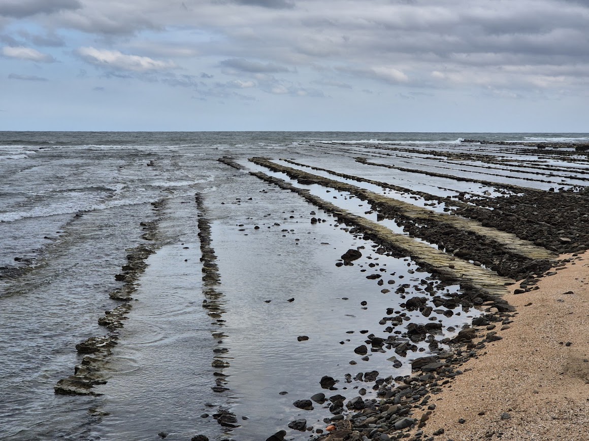
After about 4 km into our drive from Aoshima, we made a quick stop at Horikiri Pass. This is a nice place to view the ocean from the cliff. We could also view more of the Devil’s Washboard in the shore below us. The bed of rock has straight ridges, which are the result of erosion, giving it the appearance of an old-fashioned washboard.
 The washboard-like appearance across the beach, known as Devil’s Washboard, as viewed from Horikiri Pass.
The old coastal road down Horikiri Pass is supposed to be very scenic but it was closed. We had to backtrack to Route 220 to continue our journey southwards.
 The road down the pass was CLOSED!
Lunch at Taikai
We figured that we should have seafood while travelling along the east coast of Kyushu. The coastal areas typically served the freshest and cheapest seafood.
We decided to have early lunch at this highly recommended seafood restaurant located in Nichinan called Taikai (大海). The Kanji characters on the roof mean “Big Sea”, probably referring to the main source of the ingredients for our meal.
 View of the Taikai restaurant from the car park. Like most Japanese eating places, there is no fancy signboard advertising their food.
The restaurant opened at 11 AM. We timed our arrival just after the restaurant opens for business. Even then, there were already a few groups of people seated outside, waiting for a table. We had to register our names and waited a short time before we were ushered in. We were offered a seat at a Japanese style, low dining table, where we had to sit on cushions placed on the floor.
The restaurant provided menu in English and we had to order via a tablet. The restaurant features an impressive selection of fresh seafood, including thick-cut sashimi and flavorful lobster, all served at reasonable prices.
The restaurant is known for their Ise Lobsters (Japanese spiny lobster) which were in season. We just had Ise Lobster for dinner in Miyazaki so we decided to skip the lobster and ordered the sashimi rice bowl sets (3410 Yen per set) instead. The seafood rice bowl set came with vinegared vegetables, broth, “dutch egg” or chicken nanban, miso fish soup.
 Tasty appetiser made from seaweed.
 Dutch egg (right) and chicken nanban (left).
The “Dutch egg” was pretty tasty . We had a hard time figuring out the ingredients that probably included tofu, egg and some meat protein. The chicken nanban is tasty too. Chicken nanban is fried chicken that is soaked in sweet and sour sauce and comes with tartar sauce. It is a famous Miyazaki local food and is definitely something that is a must try when visiting Miyazaki. We actually had our first try of this savoury dish during the buffet breakfast at the Dormy Inn Miyazaki.
 Sashimi rice bowl and fish miso soup.
 The rice bowl came with Uni (sea urchin’s roe).
The seafood rice bowl came with various fresh seafood including the expensive Uni (sea urchin’s roe) and sweet Botan shrimp. The portion was generous and I was struggling to finish all the food.
We saw many of the other diners enjoying their grilled lobsters and I felt a little regret that we did not splurge on a lobster meal.
After our lunch break, we continued on our drive down the scenic coastal road to Udo Shrine. We saw signs for the entrance to Sun Messe Nichinan park that featured a row of replica Moai statues but decided to drive on. We had seen similar Moai statues in Hokkaido and was free of charge too. Hence it made no sense to pay money to see something similar.
See my blog post on the Easter Island Moai Statues in Hokkaido here.
Udo Shrine or Udo Jinga (鵜戸神宮)
Udo Shrine is located very close to Sun Messe Nichinan. Apparently there was some road works on the usual access road to the shrine and we were directed by Google Maps to use another access road. We had to turn off into Route 433 on our left side after going through a traffic tunnel on the main highway. From there, we had to turn off Route 433 onto a narrow single track road. This road hugged the coast with the sea to our right, i.e. we are approaching the shrine from the south. We had to drive carefully, as there are many turns and blind corners with cars coming from the opposite direction.
There are several car parks near the shrine and we parked at the nearest available one. This shrine is quite popular as could be seen by the number of cars in the large car park.
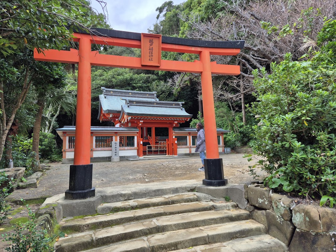
 Entrance to Udo Shrine.
 Another large gate located after the entrance gate.

We took a small detour to see the Udo Inari Shrine first. This small shrine is located on the left, just past the entrance gates.
Like the Fushimi Inari Shrine in Kyoto, the Udo Inari Shrine has a series of red torii gates lined up along the path to the shrine, located on the hillside. The torii gates at Udo is smaller in scale but still worth a few photos.
 Red torii gates at the Udo Inari Shrine.
 Udo Inari Shrine.

From the Inari Shrine, we turned left and continued down a path with bright red railings that leads to the main shrine. The main shrine is set in a cave on the side of a cliff overlooking the ocean.
 Stairs leading down to the terrace by the sea and the cave with the shrine.
 The waves crashing on the rocks on the seashore were so fascinating.
 Jagged rocks that jut out from the sea right beneath the cave.
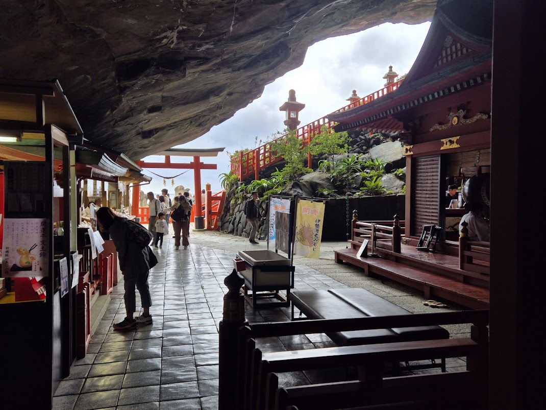
 Terrace in front of the cave shrine.
Among the rocks below, we saw a target marked by rope. The target is a hole on a large rock into which people try to throw small clay pebbles called undama (loosely translated as lucky balls). These balls are available sold from a stall by the shrine. 5 balls for 200 yen.
 Target is a hole on the rock marked by the rope.
Women throw with their right hand while men throw with their left. Landing an undama in the target brings good luck. We spent some time watching and cheering on some visitors who were testing their throwing skills or luck. More often than not, the clay pebbles missed the target. 
Fun aside, the actual shrine in the large cave was quite impressive to see.
Udo Shrine is dedicated to Yamasachihiko, the father of Emperor Jimmu, the mythical first emperor of Japan.
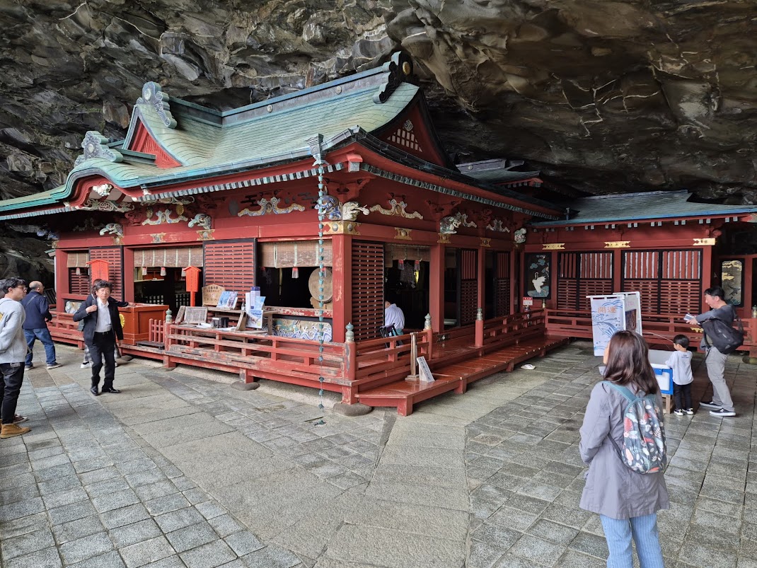 Udo Shrine in the cave.
Due to some legends or stories about Jimmu being or reared here, the shrine is famous for granting luck in love, pregnancy and safe childbirth.

 Musician playing on an instrument in the shrine.
Visitors could walk, in the clockwise direction, around the shrine.
 Smaller shrine on the left side of the main shrine.
 Wooden plaques with worshippers’ wishes hang on a rack behind the shrine.
 Stalls selling emas, charms and other souvenirs near the entrance to the cave.
Our visit to Udo Shrine marked the end of our drive down the Nichinan Coast. From there, we drove inland towards Kirishima and then Kagoshima where we would be staying for the night.


 Sekinoo Falls
 View of Sekinoo Falls and the suspension bridge at the start of the walking trail.
 The suspension bridge is the best place to view the waterfalls.
  Sekinoo Falls throws up a spray with a roaring sound as it falls down the cliff.
  Ootaki as viewed from the middle of the bridge.
 Another angle of Ootaki from near the end of the bridge.
 One of the smaller waterfalls downstream from the bridge. There is a separate walking path from the car park to this waterfall that we did not take.
  View of lower Shonai River, downstream from the Sekinoo Falls.
 View of the Shonai River at the top of the waterfall.
 “ouketsu” or potholes at the top of Sekinoo Falls.
 Concrete bridge over the upper Shonai River where we could get closer look at the potholes.
 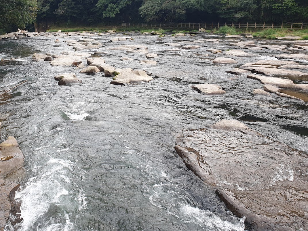 Water flowing over the cracks in the river bed or potholes.
 Long exposure photo of the flowing river.
 Another concrete bridge further upstream.